


SellaRuunda 03.02.22

francoisperez
User
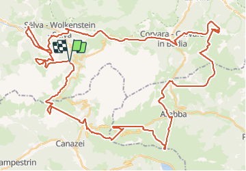

Length
70 km

Max alt
2484 m

Uphill gradient
6733 m
Km-Effort
160 km

Min alt
1410 m

Downhill gradient
6730 m
Boucle
Yes
Creation date :
2022-02-03 07:43:44.0
Updated on :
2022-02-03 15:43:14.115
7h58
Difficulty : Unknown

FREE GPS app for hiking
 SityTrail
IGN / Geographical institutes
SityTrail Plus
The world is yours!
About
Trail Alpine skiing of 70 km to be discovered at Trentino-Alto Adige/Südtirol, South Tyrol, Sëlva - Wolkenstein - Selva di Val Gardena. This trail is proposed by francoisperez.
Positioning
Country:
Italy
Region :
Trentino-Alto Adige/Südtirol
Department/Province :
South Tyrol
Municipality :
Sëlva - Wolkenstein - Selva di Val Gardena
Location:
Unknown
Start:(Dec)
Start:(UTM)
712535 ; 5157011 (32T) N.
Comments